Photo Essays

China’s Island Build-Up: The View From Space

Recent Features

Photo Essays | Security | East Asia

China’s Island Build-Up: The View From Space

Satellite images reveal the scope of China’s expanded presence.

China’s Island Build-Up: The View From Space

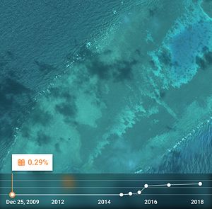
Fiery Cross Reef hosted 0.01 sq km of urbanization on December 25, 2009, as detected by SpaceKnow.

Credit: SpaceKnow
China’s Island Build-Up: The View From Space

Fiery Cross Reef had 0.13 sq km of urbanization on April 18, 2015.

Credit: SpaceKnow
China’s Island Build-Up: The View From Space

Fiery Cross Reef had 0.91 sq km of urbanization on September 3, 2017.

Credit: SpaceKnow
China’s Island Build-Up: The View From Space

In 2015, zero ships were detected off Mischief Reef by SpaceKnow analytics.

Credit: SpaceKnow
China’s Island Build-Up: The View From Space

On March 6, 2016, eight ships were detected off Mischief Reef.

Credit: SpaceKnow
China’s Island Build-Up: The View From Space

On September 3, 2016, 15 ships were detected off Mischief Reef.

Credit: SpaceKnow
China’s Island Build-Up: The View From Space

Mischief Reef Ships 4: On July 7, 2017, 16 ships were detected off Mischief Reef.

Credit: SpaceKnow
China’s Island Build-Up: The View From Space

On December 31, 2009, zero ships were detected off Subi Reef by SpaceKnow analytics.

Credit: SpaceKnow
China’s Island Build-Up: The View From Space

On January 26, 2015, seven ships were detected off Subi Reef.

Credit: SpaceKnow
China’s Island Build-Up: The View From Space

On November 17, 2016, 50 ships were detected off Subi Reef.

Credit: SpaceKnow
China’s Island Build-Up: The View From Space

SpaceKnow detected 0.00 sq km of urban infrastructure on Subi Reef on March 5, 2014.

Credit: SpaceKnow
China’s Island Build-Up: The View From Space

SpaceKnow detected 1.19 sq km of urban infrastructure on Subi Reef by March 14, 2017.

Credit: SpaceKnow
China’s Island Build-Up: The View From Space

In 2014, SpaceKnow analytics detected 0.00 sq km of land mass on Johnson South Reef.

Credit: SpaceKnow
China’s Island Build-Up: The View From Space

By April 23, 3015 SpaceKnow calculated Johnson South Reef had 0.78 sq km of land mass.

Credit: SpaceKnow

In 2015, China began pumping sand onto disputed reefs in the Spratly Island group of the South China Sea. Three years later, what used to be partially submerged coral features are now fully fledged islands, hosting buildings, ports, and runways.

SpaceKnow looked at satellite images over the past decade to analyze the increase of infrastructure, land mass, ships, and planes in the disputed South China Sea. Our analytics are capable of detecting patterns and changes over a period of time for visualizing and assessing change. We recently looked into the buildup of islands in the Spratly Islands from 2009 through 2018.  These selected images showcase the larger trends at play for some of the Spratly Islands, including an increase in urbanization as well as the deployment of boats and ships to the new facilities.

Founded in 2013 in San Francisco, CA, SpaceKnow’s mission is to provide transparent access and analytics of satellite imagery to the world. SpaceKnow’s team of imaging scientists and software engineers measure and anticipate events by analyzing patterns in the imagery data. 

Dreaming of a career in the Asia-Pacific?
Try The Diplomat's jobs board.
Find your Asia-Pacific job