The death toll from last week’s earthquake in Myanmar has now topped 2,000, with the United Nations health agency warning that the disaster has overwhelmed the country’s poorly equipped healthcare system.
A 7.7 magnitude earthquake hit central Myanmar, causing widespread destruction in Mandalay, Naypyidaw, Sagaing, Magwe, and Bago regions, along with areas in Shan State. Myanmar’s military junta announced yesterday that the death toll from the earthquake had risen to 2,056 people. It said that a further 3,900 people were injured, and announced a weeklong period of mourning during which flags will be flown at half-mast.
Across central Myanmar, volunteer rescuers continue to dig into collapsed homes and buildings in search of possible survivors, even as the chances of their recovery grow slim. According to reports from the quake zone, countless homes, schools, universities, hotels, hospitals, and religious buildings have been damaged or destroyed.
In a situation update released yesterday, the World Health Organization (WHO) said that rescue operations faced “significant obstacles including damaged roads, collapsed bridges, unstable communications, and the complexities related to civil conflict.” It also said that the disaster “has overwhelmed healthcare facilities in the affected areas, which are struggling to manage the influx of injured individuals.”
It added, “There is an urgent need for trauma and surgical care, blood transfusion supplies, anesthetics, essential medicines, and mental health support.” On top of this, the WHO reported that one private hospital and two public hospitals “have been completely damaged,” while 22 hospitals have sustained “partial damage.”
As I noted yesterday, the full extent of the earthquake remains unclear, given the contested political situation in much of the quake zone (particularly Sagaing Region) and junta-imposed internet shutdowns.
Lauren Ellery, deputy director of programs in Myanmar for the International Rescue Committee, told the Associated Press that the full scale of the destruction remained unclear. “They were talking about a town near Mandalay where 80 percent of the buildings were reportedly collapsed, but it wasn’t in the news because telecommunications have been slow,” she told the news agency. Based on predictive modeling, the United States Geological Survey has estimated that the death toll from the disaster could range between 10,000 and 100,000.
The earthquake resulted from a grinding of the Sagaing Fault, which runs north-south along the length of the Irrawaddy River valley, a rich alluvial plain that has historically contained most of Myanmar’s large population centers. While central Myanmar has experienced numerous minor earthquakes over the decades, the last event of a comparable magnitude was an earthquake in March 1839.
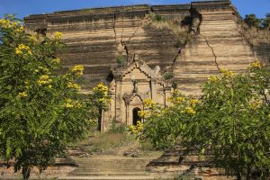
At the time, British officials recorded widespread catastrophic damage, including the near-total destruction of the then Burmese capital of Inwa, which subsequently relocated to nearby Amarapura in 1842. During the earthquake, wrote geologist Win Swe in 1981, the banks of the Myitnge River, a major tributary of the Irrawaddy, “rent in many places, presenting chasms of 5 to 20 feet in width, and large quantities of water and sand of black appearance were ejected. Causalities were estimated at 300 to 400, including a large number of monks buried under the collapsed brick monasteries.” Some of the damage from the earthquake, including the large cracks in the façade of the uncompleted Mingun Pahtodawgyi stupa outside Mandalay, remain visible to this day. According to one report, the stupa may have since sustained further damage.
According to biologist Brian Olson, who posed an informative thread about last week’s earthquake on X, the Irrawaddy valley is “filled with unconsolidated river sediments that can amplify ground shaking.” He added that based on videos of the damage, many of the buildings that collapsed appear to have been “either brick, block, or ‘soft-story’ construction,” all of which are “prone to collapse during strong ground shaking.”
The Muslim communities of Mandalay and Sagaing regions appear to have been disproportionately affected by the disaster. According to the Spring Revolution Myanmar Muslim Network, the earthquake destroyed more than 60 mosques in the two regions, The Irrawaddy reported. Among them was the Shwe Phone Shein mosque, Mandalay’s oldest Muslim house of worship, the collapse of which killed an estimated 20 worshipers.
The region’s historic mosques, some of which date back to the late nineteenth and early twentieth centuries, were particularly vulnerable due to years of neglect. In 2017, the U.S. State Department reported that the government had made it difficult for Myanmar’s Muslims to obtain permission to build and repair mosques, an outgrowth of the longstanding discrimination against the Muslim minority. As a result, historic mosques had “continued to deteriorate.”
Whether such repairs would have made much difference, given the scale of the earthquake, remains unclear, but the fact that the quake also hit in the middle of Friday prayers means that Muslims are sadly over-represented among the quake’s victims. The Spring Revolution Myanmar Muslim Network estimates that more than 700 Muslim worshipers were killed, some of whose bodies remain trapped under the rubble.


